
donderdag 21 oktober 2010
and that is fifty !
Today, 21 october, was the 50th thunderstorm day of 2010. In the early afternoon, thunderstorms passed my village just to the north and, for the time of year, were quite active. Also they were moving rather fast due to the high windspeeds at all levels of the atmosphere. There was also a decent vertical windshear, so this helped the organization of the storms.

zaterdag 16 oktober 2010
River valley fog
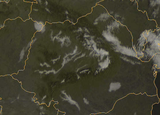
On 11 october 2010 my village was hidden in fog. Normally, this time of year the fog will dissapear (one month later and this is not so sure). It did, but I had to wait till noon before this occured.
On the meteosat (VIS) satellite picture it was nice to see that in Transylvania (and locally elsewhere) the fog was mainly restricted to river valleys. The fractal topographical structure of the rivers Mures, Olt and many others can be seen clearly:

On the meteosat (VIS) satellite picture it was nice to see that in Transylvania (and locally elsewhere) the fog was mainly restricted to river valleys. The fractal topographical structure of the rivers Mures, Olt and many others can be seen clearly:
zondag 10 oktober 2010
Thunderstorm Climatology part II
My follow-up of the thunderstorm climate of Romania.
From the extensive database of www.tutiempo.net I calculated the number of thunderstorm days for numerous places in Romania. After that I drew a map to see the spatial distribution:

Average annual number of thunderstorm days for Romania, 1991-2010. Iso-lines: pink=38, red=34, yellow=30, green=26 and blue=22.
It's clear that the central part of Transylvania and a belt just south of the southern Carpathian mountains (Transylvanian Alps) receive most thunderstorm-days, with 35 to 40 on average. This is among the highest in Europe. Other area's in Europe with comparable numbers of thunderstorm days are the southern French Alps, the Po River Valley, the Croatian coastal areas and western Bulgaria.
An other conclusion is that the number of thunderstorms decreases in east and northeasterly direction. One cause could be the dryer/more arid conditions in the east/northeast. The town of Sulina for example, with 15 annual thunderstorm days, gets only 400-450 mm of precipitation per year.
Other interesting observation is the local maximum about 20 kilometers inland from the Black Sea coast. Here thunderstorm development on the seabreeze-front is a plausible explanation for this local maximum.
For the decrease in number near the southern border I have no good explanation. On the Bulgarian side of the river Danube, the annual number is comparable to that of extreme southern Romania. However, further to the southwest it increases dramatically to around 40 near Sofia, Bulgaria.
Abonneren op:
Posts (Atom)