
donderdag 21 oktober 2010
and that is fifty !
Today, 21 october, was the 50th thunderstorm day of 2010. In the early afternoon, thunderstorms passed my village just to the north and, for the time of year, were quite active. Also they were moving rather fast due to the high windspeeds at all levels of the atmosphere. There was also a decent vertical windshear, so this helped the organization of the storms.

zaterdag 16 oktober 2010
River valley fog
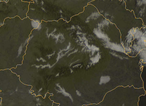
On 11 october 2010 my village was hidden in fog. Normally, this time of year the fog will dissapear (one month later and this is not so sure). It did, but I had to wait till noon before this occured.
On the meteosat (VIS) satellite picture it was nice to see that in Transylvania (and locally elsewhere) the fog was mainly restricted to river valleys. The fractal topographical structure of the rivers Mures, Olt and many others can be seen clearly:

On the meteosat (VIS) satellite picture it was nice to see that in Transylvania (and locally elsewhere) the fog was mainly restricted to river valleys. The fractal topographical structure of the rivers Mures, Olt and many others can be seen clearly:
zondag 10 oktober 2010
Thunderstorm Climatology part II
My follow-up of the thunderstorm climate of Romania.
From the extensive database of www.tutiempo.net I calculated the number of thunderstorm days for numerous places in Romania. After that I drew a map to see the spatial distribution:

Average annual number of thunderstorm days for Romania, 1991-2010. Iso-lines: pink=38, red=34, yellow=30, green=26 and blue=22.
It's clear that the central part of Transylvania and a belt just south of the southern Carpathian mountains (Transylvanian Alps) receive most thunderstorm-days, with 35 to 40 on average. This is among the highest in Europe. Other area's in Europe with comparable numbers of thunderstorm days are the southern French Alps, the Po River Valley, the Croatian coastal areas and western Bulgaria.
An other conclusion is that the number of thunderstorms decreases in east and northeasterly direction. One cause could be the dryer/more arid conditions in the east/northeast. The town of Sulina for example, with 15 annual thunderstorm days, gets only 400-450 mm of precipitation per year.
Other interesting observation is the local maximum about 20 kilometers inland from the Black Sea coast. Here thunderstorm development on the seabreeze-front is a plausible explanation for this local maximum.
For the decrease in number near the southern border I have no good explanation. On the Bulgarian side of the river Danube, the annual number is comparable to that of extreme southern Romania. However, further to the southwest it increases dramatically to around 40 near Sofia, Bulgaria.
maandag 27 september 2010
shelf, rainbow, 49th thunderstorm day
One week later, on Sunday September 26th, the situation again became interesting. With a strong southerly flow, moist warm air was rapidly advected northward over eastern Europe. Even without notable sunshine the temperature easily reached 24 C in the early afternoon.
A coldfront was approaching from the west-southwest, as can be seen on this weathermap:

Surface analyses for 26 september 2010, 00 UTC.
And yes, in the late afternoon this storm came in from the south:


When the rain and gusts were over, an extremely bright rainbow (category 5) was visible in easterly direction. For me it was the brightest rainbow in years.
These are two images of the rainbow (no photoshop here):


Till so far, NO thunder was observed with this "storm". However, when it moved further east, it activated enormously and I observed thunder & lightning at the back of the storm, so I could write the 49th thunderstorm day of 2010 in my observation-book.
A nice squall line with embedded discete cells at the front and trailing stratiform precipitation, developed over the eastern Carpathian mountains in the course of the evening:

maandag 20 september 2010
last thunderstorm of the year ?
Sunday evening, September 19th, a coldfront came in from the west-northwest. On the front edge of the precipitation area thunderstorms developed. For the time of year they were rather active thunderstorms. Lightning activity was around 15-20 flashes per minute at it's peak. Also there were a few exceptionally bright CG's (cloud to ground lightning) nearby. Even with a setting of f/10 on my photo-camera they caused a completely white-out of the image.....
Because of the heavy rain and because the thunderstorms were a bit unexpected, I couldn't make much images.

Autumn is a short season in Transylvania, so it is likely that this was the last thunderstorm of the year.
Because of the heavy rain and because the thunderstorms were a bit unexpected, I couldn't make much images.

Autumn is a short season in Transylvania, so it is likely that this was the last thunderstorm of the year.
woensdag 1 september 2010
high shear, very low cape
In the early evening of Friday, august 27th 2010, nice altocumulus lenticularis forms were observed:

Here, these clouds are often indicative that a coldfront is approaching.
On Saturday there were minor chances for thunderstorms. But if they developed, they could be supercells, i.e. storms with a rotating updraft.
Chances were low, because the dry air in the lowest layers and high temperatures aloft, created a thermodynamic profile with almost no CAPE (a measure of instability). This can be seen in the prog-sounding for my location. The vertical windshear is strong with a windspeed 58 kt at 500 hPa.

This situation was also well forecast by ESTOFEX:
...Romania, Ukraine...
Large wind shear and curved hodographs are favorable for supercells with large hail, but it is unlikely that with such low instability as indicated (<200 J/kg) something can develop.
Nonetheless, late in the afternoon I observed an interesting cloud-structure:

 Same photograph as above. An inflow-band (orange arrow) is feeding this "wannabe storm" from the north. As often the low-level wind was modulated by the river Mures valley and not from the northwest as indicated by the gfs-model. In light blue the cloud movement at the lower mid-levels. In dark blue the cloud movement at "anvil" level.

It was a light shower by then and I felt a few raindrops falling out of the cloudband. Thunder was not observed.

The shower struggled and struggled, but due to the low instability it didn't succeed in developing into a storm. Finally it collapsed due to the strong windshear and entrainment.
On radar I saw that about the same time, behind the eastern Carpathian Mountains near Bacau, one storm succeeded in becoming a strong cell. Perhaps this one caused severe weather over there?

Here, these clouds are often indicative that a coldfront is approaching.
On Saturday there were minor chances for thunderstorms. But if they developed, they could be supercells, i.e. storms with a rotating updraft.
Chances were low, because the dry air in the lowest layers and high temperatures aloft, created a thermodynamic profile with almost no CAPE (a measure of instability). This can be seen in the prog-sounding for my location. The vertical windshear is strong with a windspeed 58 kt at 500 hPa.

This situation was also well forecast by ESTOFEX:
...Romania, Ukraine...
Large wind shear and curved hodographs are favorable for supercells with large hail, but it is unlikely that with such low instability as indicated (<200 J/kg) something can develop.
Nonetheless, late in the afternoon I observed an interesting cloud-structure:

 Same photograph as above. An inflow-band (orange arrow) is feeding this "wannabe storm" from the north. As often the low-level wind was modulated by the river Mures valley and not from the northwest as indicated by the gfs-model. In light blue the cloud movement at the lower mid-levels. In dark blue the cloud movement at "anvil" level.
It was a light shower by then and I felt a few raindrops falling out of the cloudband. Thunder was not observed.

The shower struggled and struggled, but due to the low instability it didn't succeed in developing into a storm. Finally it collapsed due to the strong windshear and entrainment.
On radar I saw that about the same time, behind the eastern Carpathian Mountains near Bacau, one storm succeeded in becoming a strong cell. Perhaps this one caused severe weather over there?
zaterdag 28 augustus 2010
Thunderstorm Climatology part I
Summer is ending soon, here in Romania. For thunderstorms it was a rather good year with numerous thunderstorms, although most thunderstorms were of the airmass thunderstorm type. Well organized storms didn't occur often.
On average nearly 40 thunderstorms days do occur here in central Transylvania. To see how this is distributed over the year I did some statistical research. And this is the result:

Table 1. Number of thunderstorm days for LRTM (Tirgu Mures) for the last 20 years. Data extracted from www.tutiempo.net
Season starts rapidly in the month of May, with July as peak month. However, my experience is that most severe thunderstorms do occur in the month of June, when the jet-stream is stronger. In July and August the jetstream shifts to the north (on average of course). Rapid decline of the number of thunderstorm-days is from August to September when, again on average, dry arid conditions are the norm. Besides, the air in the upper levels is warmer by then, reducing the instability.
Because the continental airmass in winter is often cold and stable, winter thunderstorms are extremely rare in Transylvania. However they do happen in the period december till february: once in four or five years or so. Mainly in cases with an active coldfront or in a situation with wintry showers in northwesterly flow.
At last I will show my own observations of thunderdays from the village of Curteni (near Tirgu Mures) with data from the last three years:

* This number may change
Table 2. Number of thunderstorm days for Curteni in the period oktober 2007 - august 2010.
Abonneren op:
Posts (Atom)