
On Friday 1 July I witnessed the approach of a multicell storm. The storm came in from the northeast and showed all characteristics that can be found in textbooks.
As far as I know, besides thunder and rain, it didn't produce severe weather, but it was just fun to watch.....


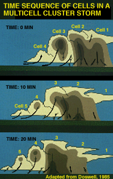
The multicell storm consists of a group of cells moving as a single unit, with each cell in a different stage of the
thunderstorm life cycle. As the multicell cluster evolves, individual cells take turns at being the most dominant.

A multicell storm forms when new convective cells develop along the boundary of the cold pool originating from an older cell. Such a boundary is often called an outflow boundary or gust front.These new cells tend to form along the upshear side of the storm, with mature cells located at the center and dissipating cells found along the downshear portion of the storm. Downshear is the direction from which the low- level wind blows when moving with the average wind (the movement expected for individual storm cells).

 The average cell undergoes a life cycle that typically spans an hour or less, though the parent storm can survive for many hours. The longevity of the multicell storm is largely due to its ability to continually generate new, replacement cells as older ones decay.
Geen opmerkingen:
Een reactie posten