woensdag 11 augustus 2010

Hail and Lightning

Last weekend, in a moderate southerly upper flow regime, a lot of thunderstorms developed over Romania.
In the evening of Friday 6 august I had the opportunity to watch and photograph the first good night-time thunderstorms of 2010:


Saturday afternoon numerous storms developed in Transsylvania. Here is a satelite-image of 17:45 local time with many "small" anvils blowing north by the southerly upper flow.


In the early evening an interesting small storm developed just to the S-SE of my place.


Despite the moderate southerly flow (30-35 kt at 500 hPa) this developing storm was almost stationary for about 20-25 minutes.


Main cause for this was that surface winds where from a northwesterly direction, as can be seen in the GFS prognostic sounding for 15 UTC. However, surface winds were not 3 kt as indicated by the sounding but an estimated 10-15 kt. It is likely that this had impact on storm-motion, although it cannot explain the stationary character for 100%. Nonetheless, 0-6 km (vectorial) windshear was increased to 35-40 kt, which is sufficient for well-organized storms.


I observed thunder and when precipitation started, the storm started moving (slowly) north, because the storm grew to the tropopause, and was steered by the stronger mid-level and upper winds.
In the village where I live, rain turned into a rain/hail mix for a few minutes, with largest stones of 1,5 cm (0.6 inch). Not that big, but a few stones showed an interesting appearance: one stone with a double embryo and clear ice around it.


"Hailstones grow by collision with supercooled water drops. Supercooled drops are liquid drops surrounded by air that is below freezing. There are two methods by which the hailstone grows, wet growth and dry growth. In wet growth, the hailstone nucleus is in a region where the air temperature is below freezing, but not super cold. Upon colliding with a supercooled drop the water does not immediately freeze around the nucleus. Instead liquid water spreads across tumbling hailstones and slowly freezes. Since the process is slow, air bubbles can escape resulting in a layer of clear ice."


Later in the evening active thunderstorms in the north and northeast caused some nice CG's.


One day later (Sunday 8th), this was repeated, but then most lightning was in a southerly direction:


What you see here occured in the whimp of an eye: all the lightning flashes stroke within one second.

zaterdag 7 augustus 2010

Linear Pulse-like Storm: whalesmouth and blowing dust

On August 5th, halfway te afternoon, storms fired over the southern Carpathian mountains (near Brasov). With a southerly flow the storms were advected to the Transsylvanian basin where they tapped into a more moist and unstable airmass. There the storms rapidly arranged in a linear storm system.


The sounding of Bucurest was (in this case) representative for the airmass and windprofile of the area where the storms developed. Fairly large instability (CAPE over 1800 J/kg) and moderate vertical windshear. This explains the further development of the line of storms, which can be seen in the following radar-images:


17:20 lt


17:50 lt


18:20 lt


The storms were moving with a speed of approximately 60 km/hr to the north-northwest. In the middle radar-image perhaps a shortlived small bow is visible. From that time, the line rapidly desintegrated due to the imbalance between CAPE and SHEAR.
Although linear, this storm behaved like a so called pulse storm, which can briefly cause severe weather. The vertical windshear was too low to support a storm-system with well defined separate up- and downdrafts. Also due to the strong outflow, the gustfront moved away from the the line of storms. With stronger windshear the gustfront remains close to the storms. Only then deep convection can organize and develop into a self-sustained long-lived storm-system.

Nonetheless, when the storms reached the Tirgu Mures area, spectacular skies appeared in southeasterly direction:


Out of the hazy layers a sort of battleship appeared.


I was expecting a shelfcloud, instead a large whalesmouth rapidly moved over my position. Notice the large curved front-edge of the whalesmouth.


Perhaps here a small shelf is visible?


The wind is getting stronger, also some small funnel-look-alikes are visible on the front-edge where inflow meets outflow. Sometimes they become longer and small scuds are moving upward beneath. They aren't rotating and after ten of twenty seconds they disappear.


Dust is kicked up by the strong winds. On the picture one can see tree-crowns are blown nearly horizontal.


Skies are changing with every second that passes. Also there are white holes in the turbulent sky: high contrast, so rather difficult to photograph.


Best skies are in the north now, so I go to our street where horses show up out of the blowing dust....


Hmmm, this one is already halfway the distance cloud-earth. The border between inflow and outflow is where things got interesting today.....


At last a satelite image of 18:15 local time. For an animation of the images click HERE

dinsdag 3 augustus 2010

fragmented shelfcloud

In the early evening of the first day of august 2010 I observed a nice fragmented shelfcloud.


A SE-NW moving thunderstorm complex with highest radar reflectivities at the front approached the Tirgu Mures area. Since winds at all levels of the atmosphere were low, rather slow moving thunderstorms were the result.


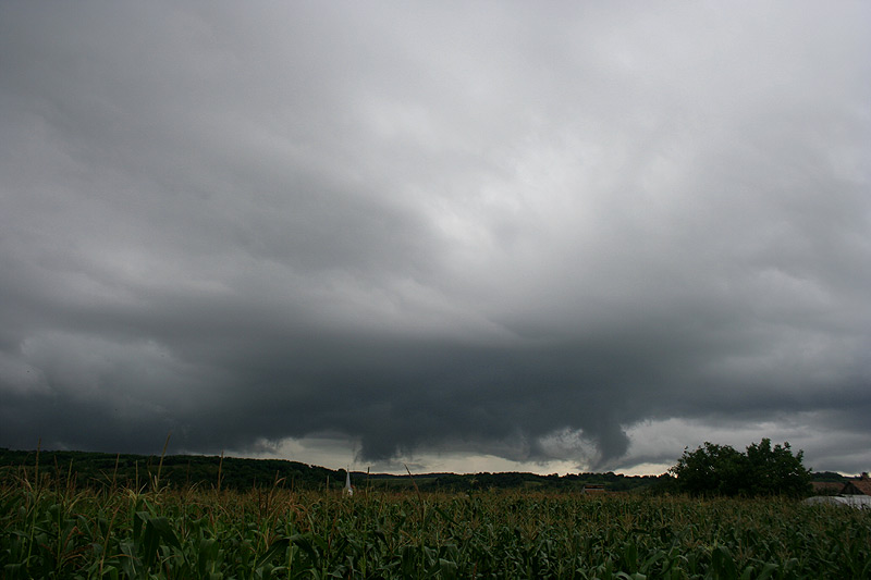
At first sight it seemed a solid shelfcloud was approaching, but when it came closer from the east, it was clearly fragmented. Nonetheless, the clouds I observed were nice to watch:


This was a bit better than all the airmass thunderstorms from the last two weeks. In an environment of moderate instability and low vertical windshear this is the best you can get, I guess. Also I think I was just lucky to be in the right place, since the outflow moved away from the thunderstorm-complex, which couldn't organize well because of the petty shear.

zondag 1 augustus 2010

July 2010 Reprise

A few photographs from last month of July which were not published in my blog:


Thunderstorm with strong updraft in the late afternoon of 13 July.


Two pictures of a rather flat, blocked shelfcloud in the evening of 13 July.


Anvil with sheet lightning in the evening of 13 July.


First decent lightning-shot of 2010 in the evening of 13 July.


Strange, extremely high towering cumulus in the early evening of 19 July.

maandag 26 juli 2010

Showers in polar air

In the early evening of Sunday 25 July 2010, dark-based showers with a manacing look, moved slowly in north-northeasterly direction. For a short time I observed weak rotation in lowered ragged fractus clouds beneath the base. After that the shower came in from the northwest and moved slowly southeast. So direction had changed!


I think that a convergence-line/surface trough was in my neighourhood and caused this change of movement of the shower. It is possible that a pre-existing vortice in the surface windfield became stretched in the updraft and caused the observed rotation. Perhaps the late day-time/weak instability prehibited the forming of a real funnel.


This was not the first time that showers/thunderstorms in a (modified) polar airmass showed some nice visual sights.


Here a bonus-image of the sunset of 23 July with dissipating convection (at that time the airmass was still warm and humid).

donderdag 22 juli 2010

Airmass Thunderstorm

Till July 22nd, I already counted 15 thunderstorm-days this month, which is above normal. Most of these thunderstorms are of the type which meteorologists describe with the term airmass thunderstorms.


Airmass thunderstorms develop in the course of the day due to the heating of the surface, and rapidly dye out after sunset.
The life cycle of one cell takes typically 30 to 50 minutes. They usually are not strong enough to produce severe weather.


A true single cell storm is actually quite rare. Even with isolated storms in weak vertical wind shear, the gust front on one cell often triggers the growth of another cell some distance away.
Single cells in this way form the building blocks of larger convective systems.


Thunderstorm in the direction of Bistrita, Romania. 21 July 2010.


In the late afternoon/early evening of 21 july, such a single cell developed exactly over my location. Since there was hardly any wind on all levels of the atmosphere, it didn't move and dropped it's precipitation right on the village where I live.


Radar-image of 21 July 2010, 18:40 local time.


VIS satellite-image of 21 July 2010, 19:15 local time.


And here the result..... more than 20 mm of rain in about three quarter of an hour.


One day later (22 July) another round of airmass thunderstorms produced some photogenic oportunities:


Growing thunderheads in easterly direction.


Nice downdraft from a cell in the north. It produced moderate gusts (estimated 25 kt) when reaching my location.